
Everyone lives on waterfront property. If you live near the Great Lakes Watershed Basin no matter if it’s located on a river, lake or inland.
Everything we put, pour or dump on our land eventually finds is it’s way into the ground water, rivers, streams, drinking wells and ultimately the Great Lakes.
All the threats listed here are a direct result of human activities.
Check out the Restore the Great Lakes project page to learn how we can start protecting and restoring right now!
")
Industrial Pollution

Dead fish in Lake Michigan in northwestern Indiana from a chemical spill of excess amounts of cyanide and ammonia-nitrogen were dumped into the river’s east branch, causing a fish kill from a steel factory into the Little Calumet River caused fish to die in the area. Source
Industrial Animal Factories (CAFO)

Flooding of a CAFO, the animals standing in several feet of their own excrement which eventually finds its way into waterways including Western Lake area which directly contribute to Harmful Algae Blooms and the proliferation of Cynobacteria Source: here
CAFO Violations

Photo credit Water Front Line
4,711 violations, 2000-2020 – this is a conservative list, noting only violations documented by federal and state agencies. Confirmed Violations/Discharges from CAFOs and Liquid-System Livestock Operations to Bean/Tiffin Watershed and River Raisin Watershed. Source
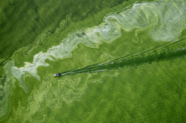
Lake Erie Algae Bloom

Photo from NRDC
https://en.wikipedia.org/wiki/Cyanotoxin

Lake Erie Algae Bloom Source
Dumping Grease
Household Chemicals
Sewage Discharge (Combined Sewer Overflow)

Photo: Photo provided Green Learning Station at the Civic Garden Center of Greater Cincinnati)
A combined sewer system (CSS) collects rainwater runoff, domestic sewage, and industrial wastewater into one pipe. Under normal conditions, it transports all of the wastewater it collects to a sewage treatment plant for treatment, then discharges to a water body. Many times the wastewater exceeds the capacity of the treatment plant (during heavy rains or snowmelt). When this occurs, our government releases raw untreated wastewater / industrial waste directly to nearby streams, rivers, and other water bodies.
There are 152 NPDES permits which authorize discharges from combined sewer overflows (CSOs) to the Great Lakes Basin. Select the tabs below for the list of CSO permits in the Great Lakes Basin in each state. Source
As far back as 1910, former President Theodore Roosevelt addressed the subject.
“Civilized people,” Mr. Roosevelt said at an event in Buffalo, “should be able to dispose of sewage in a better way than by putting it into drinking water.”
Oil Leaks / Spills

Oil Spill On the Detroit River, Flowing Toward Lake Erie, 1959
Oil Spill Threats in the Great Lakes Watershed Basin

Automobile Oil Spills


How many gallons per day leak into waterways via leaky oil pans? Just do the math!

A single drop of oil in water. An ounce of spilled oil can pollute 120,000 gallons of drinking water and a single pint can cover an entire acre of water! Source
Boat Leaks

Photo By Voyager Village
Oil Pipelines
Nuclear Threats

The map indicates 38 existing operating nuclear power plant sites, most are within one kilometer of the Great Lakes or the St. Lawrence River.
Heavy water leak at Ontario nuclear reactor contained: OPG spokesman Neal Kelly says they don’t know the exact amount but estimate about 7,000 litres of heavy water leaked during routine maintenance Tuesday afternoon, while the reactor was running.

Toxic Coal Ash
There are 25 Coal-fired Power Plants in the Great Lakes Region contributing to half of the Region’s Mercury Pollution. Coal ash pollutes groundwater across the nation. The Great Lakes reigion is one of the most sites polluted with coal ash. Source
Great Lakes Plastic Pollution
Over 22 million pounds of plastic pollution flows into the Great Lakes every single year, and each year this number increases. Source
Landfills Near The Lakes
When it rains on a landfill it produced leachate which pollutes groundwater. The Great Lakes have a relatively high number of landfill disposal sites located in or near the Watershed Basin.

Source: Save On Energy
Great Lakes Superfund Sites
")
There are 40,000 federal Superfund sites across the country, and approximately 1,600 of those sites have been listed on the National Priorities List (NPL). Sites on the NPL are considered the most highly contaminated waste sites which contain highly hazardous substances and undergo longer-term remedial investigation and remedial action (cleanups).
A map of Superfund sites as of October 2013. Red indicates currently on final National Priority List, yellow is proposed, green is deleted (usually meaning having been cleaned up). Source.
Why do these Superfund sites pose such a significant risk to the the Great Lakes? Because, the entire lifecylcle of the Superfund site from inception to long after (we’re talking centuries), can leak into ground water and discharge into the Great Lakes Watershed Basin.
Superfund Sites in Great Lakes Region Below;
Mining Throughout The Basin

More than 2,000 acres of unreclaimed strip mines are interspersed througout in the watershed basin. As a result, acid mine drainage directly drains into more than 20 miles of streams in the watershed. In addition, pollution from agriculture, wastewater, nutrients, and sedimentation due to abandoned mines and stream bank clearing is evident throughout.
http://minerals.ohiodnr.gov/abandoned-mine-land-reclamation/aml-reclamation-programs
Unreclaimed Mines

Acid mine seep called “Bat Gate” in Sulfur Spring Hollow, Ohio. Picture by John Sabraw of Toxic Artwww.johnsabraw.com

Herbicide use on railway tracks


Thousands of gallons of toxic herbicides are sprayed on tracks every year to destroy all vegetation.
https://www.sciencedirect.com/science/article/abs/pii/S037842749900048X
Great Lakes Areas of Concern are designated geographic areas within the Great Lakes Basin that show severe environmental degradation. There are a total of 43 areas of concern within the Great Lakes, 26 being in the United States, 17 in Canada, with five shared by the two countries.
https://en.wikipedia.org/wiki/Great_Lakes_Areas_of_Concern
Hydraulic Fracking

Source Food & Water Watch
https://www.nrdc.org/stories/fracking-101
https://en.wikipedia.org/wiki/Environmental_impact_of_hydraulic_fracturing
https://en.wikipedia.org/wiki/Hydraulic_fracturing
https://www.aiche.org/academy/product-bundles/water-concerns-hydraulic-fracturing-fracking-bundle
Dammed Rivers & Tributaries

Photo source
When tributaries get dammed, it impedes the natural flow of water and river nutrients and sediment both to and from the Great Lakes. This harms the diversity of native fish populations and lake species by blocking routes between spawning, nursery and crucial overwintering habitats. Source
More Threats Below
Point-source pollution
This form of pollution occurs when harmful pollutants enter a waterway directly.
Nonpoint source pollution
This form of pollution results from runoff from streets, lawns and farms,
Atmospheric pollution
Pollution that falls from the sky in the form of rain, also known as acid rain.
Agua Salina
Commercial Water Bottling
Pet Waste
Chemical Spills
Pharmaceutical
Herbicides ( Industrial, residential, railroad
Aqua Salina
Heavy Metal
Weak Regulation
Pet Waste
Lawn Fertilizer
Pesticides
Herbicides
Nuclear Waste Leakage
Habitat Destruction
Construction Waste